How to choose a car navigator
Software
Choosing a car GPS navigator is quite simple. You just need to adhere to a certain algorithm. First decide which navigation programme (software) you will use. It depends on which navigation maps you will have to navigate. Having understood this issue, you will be able to find out which model of the navigator will suit you more. Currently, there are many popular navigation programs — Avtospustnik, Garmin, Navitel, Navigator, iGo, CityGid, etc. Each has its own peculiarities of building routes, traffic jams, updates, etc. A good option is to buy an automatic navigator with the possibility of installing additional software. Such GPS navigators include: xDevice, Lexand, Prestigio, Ritmix.
What the maps will tell you about
Maps for GPS navigators are vector (routable) and raster (non-routable). Vector maps support automatic route creation. This is very convenient when traveling in the city and on suburban highways. You only need to set the starting point and the final stop, and GPS will independently plot the optimal route. Raster maps are topographic or satellite maps. There is no way to automatically plot a route here, but it can be done manually by plotting the intended trajectory of movement with node points. During the trip, the navigator will inform (with on-screen pointers and voice) about the approach to the nodal points and the change of direction (when turning). Non-routable maps are suitable for areas where roads are bad or there are none at all.
We are avoiding traffic jams
The next question that needs to be decided is what functions should the model you have chosen support? Choosing the maximum number of options is not always justified. If you are a resident of a small town where there is no congestion, or plan to use GPS exclusively for long-distance trips, then purchasing a device with a module for detecting traffic jams is a waste of money. But if traffic jams are a problem that you have to face all the time, such a module is vital. There are three ways to download traffic information: via Bluetooth phone with DUN function, via GPRS channel in navigators with GSM/GPRS module and using FM traffic antenna. In the first and second cases, the information is downloaded through a special communication channel with the GPRS Internet, which is used for cell phones. But in the first variant, the connection works much slower. However, this way you will save money, because the second option with a built-in GSM /GPRS module is expensive. But the way to pay less is the network in this case: you can insert a SIM card with your number and a special tariff into the device, thus getting GPRS traffic from the Internet cheaper. Traffic jams will be loaded faster, and communication will become more reliable.
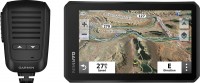
Important options
Also, when choosing GPS, the following aspects should be taken into account::
- the diagonal of the navigator's display can be from 3.5 to 7" or more. A wide display is needed if you want to use the navigator to watch videos or if you have poor eyesight;
- the presence of Wi-Fi in the navigator will be useful if you get into a free Internet access zone;
- The FM transmitter will allow you to send sound (voice signal, etc.) to the car radio without audio cables;
- the "road information" function: depending on the navigator programme, the display shows the maximum and average speed, the amount of fuel in the tank, its consumption and other important parameters;
- it is very convenient if the navigator has support for memory cards - you can fill all the necessary information into the device's memory.
A trifle, but nice
It also makes sense to pay attention to a number of "little things" that will make using the navigator as convenient as possible. For example, if you intend to purchase a navigator with a raster map, ask what is the maximum number of points that can mark the selected route. Don't forget to check how many colours the display supports – in cheap versions, the image is only in grayscale. Estimate the amount of memory – the larger it is, the more maps and a more detailed scale can be downloaded. An important characteristic is the processor power. The speed of zooming and scrolling of the map will depend on it.
Is it cheap, is it expensive
Regardless of the manufacturer, navigators are usually divided into four categories. Each has its own set of features, which determines the cost of the model. The first category is low-cost, performs the function of navigation and 1-2 additional ones. The maximum price for today is up to $ 130 dollars. Next comes the mid-level category, which involves navigation, multimedia and wireless connectivity. The price is within $130 – 250. High-level navigators can be recognized by a wide screen from 5 to 7", high resolution images in HD format, as well as the presence of modules: FM, GSM, Bluetooth, Wi-Fi. The price is about $250 – 380. Top-end GPS navigators cost over $380. They use the latest communication protocols, have a modern set of multimedia, unusual functions, and are distinguished by an ultramodern design. Owners of laptops or PDAs can purchase a GPS-navigator set-top box. It only works in conjunction with these devices. It costs between $110-170.
Caution - brand!
When making a choice between devices from different companies, it is worth considering that well-known manufacturers, for example, Tom-Tom, GARMIN, Mio, make a big mark-up for a famous brand, so very often the price does not match the capabilities of the model. Such car navigators as xDevice, Prestigio, Lexand, Ritmix and some others, usually, are no worse in quality and reliability than market leaders, and their prices are more democratic.


Articles, reviews, useful tips
All materials
